
Climate Table Sylt
Jan | Feb | Mar | Apr | May | Jun | Jul | Aug | Sep | Oct | Nov | Dec | |
|---|---|---|---|---|---|---|---|---|---|---|---|---|
| Max. Temperature | 3° | 3° | 5° | 9° | 14° | 17° | 19° | 19° | 16° | 12° | 8° | 5° |
| Min. Temperature | -1° | -1° | 1° | 4° | 8° | 12° | 13° | 14° | 12° | 9° | 4° | 1° |
| Sun Hours | 2 | 3 | 4 | 6 | 8 | 8 | 7 | 7 | 5 | 3 | 2 | 1 |
| Water Temperature | 4° | 3° | 4° | 6° | 10° | 13° | 16° | 17° | 15° | 13° | 9° | 6° |
| Rain Days | 12 | 8 | 10 | 9 | 8 | 9 | 11 | 11 | 13 | 13 | 16 | 13 |

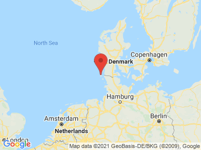
Map view of Sylt
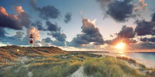
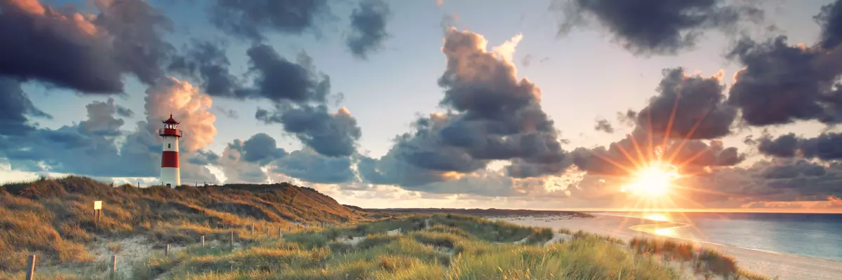
The climate year of Sylt
Sylt is the northernmost German island and became famous for its health resorts Westerland, Kampen and Wenningstedt. A 40 km long sandy beach is located on the west and northwest side of the island, on the east side lies the Wadden Sea, which is part of the Schleswig-Holstein National Park. The dune areas are protected and may only be entered on marked paths, since a "wild walking" of the dunes destroys the vegetation and is then worn away by wind and water. The Wadden Sea on the eastern side has also been a nature reserve and bird sanctuary since 1935. Sylt has a healthy island climate with a unique nature that attracts tourists all year round. Already in the 19th century, when tourism began, many artists such as Emil Nolde, Julius Bodenstein and Ernst Mollenhauer and the writer Thomas Mann spent the summer months on Sylt. It is not so warm here in the summer months and in winter Sylt has higher temperatures than on the mainland.
General information about Sylt
A fascinating point of the island is the west coast with the Red Cliff. With certain sun and light irradiation the rock glows red and spreads a peculiar mood. In Listland, also on the west coast, visitors can observe the last shifting sand dune in Germany, which travels seven meters per year. An important nature reserve is the Vogelkoje in the north of the island. A green biotope has been created here, giving migratory birds an important resting place on their journey. A hike through this area opens up beautiful views of the waves of the North Sea and in summer the pink heather blooms. If you are interested in the largest stone tomb in north-western Europe, you should visit the Denghoog barrow. To this day, no one knows exactly where and how these huge stones were brought here almost 6000 years ago, but it is interesting to learn more about it during a guided tour.
Tourism Sylt
The maritime climate, influenced by the Gulf Stream, is milder than on the mainland, averaging 2°C. The summer months show an average of 17°C on the thermometer and are a little cooler. On average, the sun shines on Sylt for 4.6 hours per day. The most hours of sunshine are attributed to the months of May to August, which are at the top with an average of 7 - 8 hours. Rainy days from September to December there are between 13 and 16 per month the fewest from February to June. The water temperature remains at a cold 16°C to 17°C on average even in the summer months of July and August, and everyone must decide for themselves whether they prefer to go to the wave pool.